Hiking in Switzerland
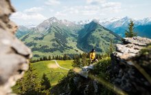
Do you like the idea of a day of hiking across diverse terrains amidst majestic mountains and tranquil valleys? Or even better, why not stay at a youth hostel in the heart of Switzerland’s most stunning hiking regions and turn a day of hiking into a hiking holiday!
Tours and hiking tips
There are 65,000 kilometres of well-marked hiking trails in Switzerland. Lace up your hiking boots and experience the diversity of Switzerland step by step.

From Wilderswil, you take the cogwheel railway to the Schynige Platte mountain ridge. This is where the hike starts and leads past the alpine huts from Oberberg to the western slope of Mount Loucherhorn. The vegetation within the karst landscape of the Güw region is sparse and fragile. Walking via Egg, you gradually ascend along the flank of the Sägissa, descending towards shimmering sunlight reflecting on the waters of the small Sägistal lake. The trail continues past the Berghaus Männdlenen, climbing steadily to Fulegg, then along the southern slope of the Faulhorn peak and on to its summit.

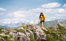
This hike starts in Pontresina. You then climb up to Fuorcla Surlej and from there continue to the Corvatsch Murtèl midway station, where you can enjoy a wonderful view of the Engadin Lake Plateau. For even more fabulous panoramic views, take the cable car up to the Corvatsch summit station.
The reverse route from Silvaplana is less strenuous. Take the aerial cableway up to the Corvatsch midway station and from there walk towards Pontresina.

With its unique mountain panorama – featuring the iconic Matterhorn, of course – and authentic refreshment stops, this popular tour does not entail any significantly difficult ascents or descents. Are you daring enough to take an ice bath in the crystal-clear Grünsee lake before travelling back from Riffelalp on the Gornergrat Railway to Zermatt?
Family-friendly hikes
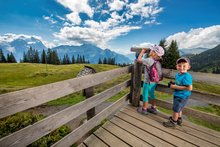
From barbecuing to bathing, from climbing to getting messy – on walks with children, it’s all about variety and sparking moments of ‘aha’ and ‘ooh’!

The Hasli dwarfs have a long tradition in the Hasli Valley, and Muggestutz is the oldest Hasli dwarf. He has countless adventures along the Mägisalp-Bidmi Dwarf Trail and invites you and your crew into his captivating world. It’s not just kids who love the exciting stories and discovery stations on the dwarf hiking trail, which is around 5 km long. Ready, set, go!

Ibex fans can learn all about Graubünden’s heraldic animal on the Ibex Promenade, a one kilometre-long, pushchair-friendly hiking trail. The fun of learning and exercising continues straight away at the Langguard chairlift mountain station, where you will find an ibex gallery and playground.
Grab an Ibex pass at the tourist information office, hike to the Unterer Schafberg, Chamanna Paradis, Chamanna Segantini and Chamanna Georgy mountain huts, solve the riddles and earn a reward!

On this informative themed trail, you and the rest of your crew will be accompanied by Barry and Hans, the two main characters from the Swiss fruit advertising campaign. It’s a great way to learn all about apples. Information panels, audio activities, a competition and beautiful picnic spots are just as much a part of this hike as the unobstructed views of the Eiger, Schreckhorn and Wetterhorn mountains.
Zermatt five-lake trail
With its unique panoramic views of the mountains – featuring the iconic Matterhorn, of course – and authentic refreshment stops, this popular tour does not include any difficult ascents or descents. Are you daring enough to take an ice bath in the crystal-clear Grünsee lake before travelling back from Riffelalp on the Gornergrat Railway to Zermatt?
- Distance: approx. 2 hours 35 mins
- Ascent: 260 metres in altitude
- Descent: 540 metres in altitude
- Highest point: 2,574 metres above sea level
An enchanting glacier landscape on Mount Corvatsch
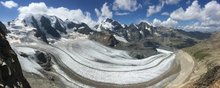
This hike starts in Pontresina. You then climb up to Fuorcla Surlej and from there continue to the Corvatsch Murtèl midway station, where you can enjoy a wonderful view of the Engadin Lake Plateau. For even more fabulous panoramic views, take the cable car up to the Corvatsch summit station. It’s useful to know that the reverse route from Silvaplana is less strenuous. Take the aerial cableway up to the Corvatsch midway station and from there walk towards Pontresina.
- Distance: approx. 4 hours 45 mins
- Ascent: 1,092 metres of elevation gain
- Descent: 163 metres in altitude
- Highest point: 2,754 metres above sea level
Schynige Platte
From Wilderswil, you take the cogwheel railway to the Schynige Platte mountain ridge. This is where the hike starts and leads past the alpine huts from Oberberg to the western slope of Mount Loucherhorn. The vegetation within the karst landscape of the Güw region is sparse and fragile. Walking via Egg, you gradually ascend along the flank of the Sägissa, descending towards shimmering sunlight reflecting on the waters of the small Sägistal lake. The trail continues past the Berghaus Männdlenen, climbing steadily to Fulegg, then along the southern slope of the Faulhorn peak and on to its summit.
- Distance: approx. 5h 30min
- Ascent: 1,026 metres of elevation gain
- Descent: 871 metres in altitude
- Highest point: 2,657 metres above sea level m.a.s.l.